Naugatuck
State Forest
Naugatuck, CT
 We always pass through the Naugatuck valley on the way north to Waterbury on Route
8.
We always pass through the Naugatuck valley on the way north to Waterbury on Route
8.
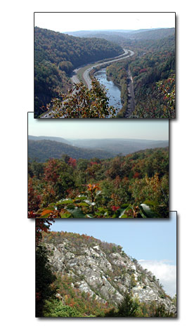
It is so scenic we decide to stop here one day in the Fall.
Vlad wanted to climb to the top of the mountain. He was surprised to find a well worn path already there.
Once at the top, he took photos of the beautiful valley.
The view is particularly beautiful at this time of year, as the trees are as colorful as they can get. There is only a period of three days where the tree leaves color peaks.
You can see the Naugatuck River as it flows along next to the highway.
I, on the other hand, stayed down below, and took pictures inside the forest, and of the mountain looking up. The mountain, which it's probably not a mountain, but a large hill, has graffiti written on it, mostly from the 1960's and 70's. It's pretty interesting to look at, and think about how in the world they got up there to do it.
There are railroad tracks that run at the bottom of the mountain, that have been there since they invented railroads. We rarely ever see anyone here at the forest, because it's not easily accessible.
Driving Directions:
Well, let's see if I can give you some directions how to access this place. Take Route 8 north and exit the Beacon Falls exit. Make a right and follow it to a stoplight where you can see a small bridge on your right. Turn at this stoplight, go over the bridge and there is a road on the right after this bridge.
So make a right and get on the road, eventually it will turn into a dirt road, but keep following it about a mile and you'll come upon a clearing with several parking spaces. Maybe there is another access to the forest, but if there is, we don't know where it's at.
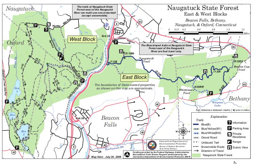
We generally have to take Exit 24, and backtrack to Main Street, Beacon Falls. The main thing is finding the street that has the bridge, which is called, Depot St. because you have to take this bridge to get to the other side of the river. We know this is the Naugatuck State Forest, but it sure doesn't say it is on our map. If there is another entrance to the Naugatuck State Forest, we haven't found it.
Email from Tom: I saw your website. You did find the sadly neglected, but beautiful Naugatuck State Forest. Another good entrance is on Old Litchfield Turnpike at the turn by Rt. 42. I attached the map for your reference. Sincerely, Tom Ebersold AMC Hike Leader Naugatuck State Forest entrance map. (The black lines are the roads.)
More Connecticut Parks
Black
Rock State Park
Pachaug State Park
Naugatuck State Forest
Indian
Well State Park
Hammonasset State
Park
Rocky Neck State Park
Southford Falls State Park
Lighthouse
Point Park
Gillette Castle
Lake
Zoar and Stevenson Dam
Colebrook Lake
Webb
Mountain in Monroe
Connecticut Campgrounds